Have you ever wondered whether or not Nigeria has heritage sites in the UNESCO list? UNESCO heritage sites in Nigeria are just two with many other nominated sites being on the tentative list.
Conservation of heritage buildings or sites is very important because it provides a sense of identity and continuity in a fast-changing world for future generations. Heritage buildings/sites basically represent the past history and culture of a nation, people or an era.
Nigeria is no doubt blessed with outstanding cultural, natural and significant heritage sites, which are listed among the UNESCO Heritage Sites. These sites exist nowhere else in the world and have become a great interest to visitors and Nigerians who long for a share of the history of the areas of these sites.
We combed through the list of the UNESCO World Heritage Sites and discovered that only two cultural sites in Nigeria were approved to be on the list while others are on the tentative list, which may be considered for nomination.
UNESCO Heritage Sites in Nigeria
Here, we present to you the list of Nigerian heritage sites, which are on both the tentative and World UNESCO Heritage sites’ lists. These sites have natural and extreme beauty with historical significance that will inspire everyone; therefore, we recommend you visit them straight-away.
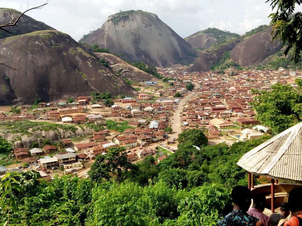
1. Sukur Cultural Landscape

This is one of the magnificent destinations that is better visited than seen on travel magazines or imagined, populated by a rich avifauna, rare species and located on top of the highest plains on the Mandara Mountains in a place called Madageli, Adamawa state. This is Nigeria’s first landmark to be inscribed on UNESCO World Heritage Site in 1999. The landscape features a palace, ritual featured terraced fields decorated with dry stones and granites, which make the village setting so natural and exceptional.
2. Osun-Osogbo Sacred Grove

This sacred forest is situated along the banks of the Oshun River, on the outskirts of the capital city of Osogbo, which is regarded as the home of the goddess of fertility – Osun. There are shrines, artworks, sculptures and sanctuaries that dot the river in honour of the goddess and other local deities. It is considered as the last of the Yoruba’s sacred forests that is still standing. In 2005, it was listed by UNESCO as a World Heritage Site. Its yearly festival brings thousands of spectators, tourists and Osun worshippers from around the world.
Below are on the tentative list of the UNESCO Cultural Heritage…
3. Alok Ikom Stone Monoliths

Akwasnshi/Atal as the monolith is called among the Ejagham people of the Cross River State is distributed among over” thirty communities. In each community, the stones are found in circles, sometimes perfect circles, facing each other standing erect, except where they have been tampered with by weather or man.
In some cases, the stones are found in the center of the village or in the central meeting place of the village elders, as in the case of Alok and Agba communities. In Etinan and Nabrokpa communities, the stones are located in an area of uncultivated forest outside the villages. The majority of the stones are carved in hard, medium-textured basaltic rock, a few are carved in sandstone and shelly limestone.
The common features of the monoliths are that they are hewn into the form of a phallus ranging from about three feet in height to about five and half feet and are decorated with carvings of geometric and stylized human features, notably two eyes, an open mouth, a head crowned with rings, a stylized pointed beard, an elaborately marked navel, two decorative hands with five fingers, a nose, various shape of facial marks.
The stone monoliths of Alok Ikom bear a form of writing and a complex system of codified information. Although they seem to share the same general features, each stone, like the human fingerprint, is unique from every other stone in its design and execution.
The geometric images on the monoliths suggest that their makers possessed more than a basic knowledge of mathematics, not only because they are geometric, but also because of the obvious implication that there were computations and numbers on the layout of the stones.
3. Ancient Kano City Walls and Associated Sites

Ancient Kano City Wall is a 14km radius earth structure, while associated sites are made up of these features, Dala Hills, Kurmi Market and Emir’s Palace.
The ancient Kano city wals were built in order to provide security to the growing population. The foundation for the construction of the wall was laid by Sakri Gijimasu from 1095 – 1134 and was completed in the middle of 14th Century during the reign of Zamnagawa. In the 16th century, the walls were further extended to their present position. The gates are as old as the walls and were used to control movement of people in and out of the city. Though, most of them are largely in ruins.
Ancient Kano city Walls and associated sites are places of spiritual, historical and cultural significance. Dala Hill was the place of the first settlement in Kano city and it formed the nucleus for the peopling of the rest of the city and was the foundation of its economic and political development.
The site bear testimony to local craftsmanship and ingenuity as is evidenced in the materials used for the construction of the walls and palace.
4. Arochkwu Long Juju Slave Route (Cave Temple Complex)

There is a six-foot gully though now covered ‘in a thickest that leads into the ancient Cave Temple. This is the main oracular shrine of Ibin Ukpabi and by which stands as if on guard the cult statue of Kamalu “the warrior god”. The site also contains an altar, which is the kitchen area. A waterfall (the loud sound of which from a distance is regarded as the prophetic voice of Ibn Ukpabi). There is also the throne of judgment – the dark presence (“the Holy of Holies”) those who were found guilty walked into dark tunnels and those found innocent returned to their relatives.
Other features include a hill of rags. That is the place where the condemned were required to undress and leave their clothes before they disappeared into the tunnels around the hill of rags. There is also the tunnel of disappearance, which is the dark tunnels into which the victims disappeared. At the site can be found the red river where it is said that as the victims disappear, the Aro would colour the river red to give people the impression that the condemned has died. And the red water flowing down the stream would be a sign to the relatives that the victims were dead. Yet another feature is the Iyi-Eke – an outlet from where the victims now blind folded walk to “Onu Asu Bekee” (the European beach, which later became the government beach) and from there, waiting boats took the enslaved to Calabar for onward transmission to Ala Bekee.
The Aros, centred around Arochukwu were able to manipulate their central oracle, Ibn Ukpabi (Long – Juju) in such a way, that it became the judicial machinery in every Igbo community. Trusting in the efficacy of the oracle, people in dispute went to settle their scores. The guilty victims became a property of the gods. They were eventually sold as slaves or retained as domestic property of the Aro Priest.
5. Benin Iya/Sungbo’s Eredo

Sungbo’s Eredo is a system of defensive walls and ditches that is located to the southwest of the Yoruba town of Ijebu Ode in Ogun State, southwest Nigeria (6.78700°N 3.87488°E). It was built in honour of the Ijebu noblewoman Oloye Bilikisu Sungbo.
The Eredo served a defensive purpose when it was built in 800–1000, a period of political confrontation and consolidation in the southern Nigerian rainforest. It was likely to have been inspired by the same process that led to the construction of similar walls and ditches throughout western Nigeria, including earthworks around Ifẹ̀, Ilesa, and the Benin Iya, a 6,500-kilometre (4,000 mi) series of connected but separate earthworks in the neighboring Edo-speaking region.
It is believed that the Eredo was a means of unifying an area of diverse communities into a single kingdom. It seems that the builders of these fortifications deliberately tried to reach groundwater or clay to create a swampy bottom for the ditch. If this could be achieved in shallow depth, builders stopped, even if only at the depth of 1 meter. In some places, small, conical idol statues had been placed on the bottom of the ditch.
Legends of the contemporary Ijebu clan link the Eredo to a fabled wealthy and childless widow named Bilikisu Sungbo. According to them, the monument was built as her personal memorial. In addition to this, her grave is believed to be located in Oke-Eiri, a town in a Muslim area just north of the Eredo. Pilgrims of Christian, Muslim and traditional African religions annually trek to this holy site in tribute to her.
6. Gashaki-Gumpti National Park

The Gashaki-Gumpti National Park is Nigeria’s largest and most diverse National Park. It is set amidst spectacular scenery with Nigeria’s highest peaks, Chappal Wadi (the “Mountain of Death”) at 2,400 meters and Chappal Hendu (“Mountain of Wind”) at 2,030 meters. The vegetation consists of an intricate patchwork of guinea savannah, gallery forest, montane forest and montane grassland. Traditional lore serves to protect some of the highest populations of primates in West Africa, including chimpanzees. Other fauna include the giant forest hog, leopard, lion, hippopotamus, buffalo, hartebeests, yellow-backed duiker and an abundance of birdlife.
7. Kwiambana and/or Ningi

Kwiambana is a ruined settlement in what is now the Kwiambana Forest Reserve. Kwiambana ruins lie on and around a twin-peaked granite inselberg in what has been until very recently a relatively inaccessible area of the Kwiambana Game Reserve. The well-preserved mud structures are enclosed by a five- to seven-meter-high bank and ditch which becomes a mud-block wall with loopholes where the circular town wall passes over bare rock and is a natural coursed rubble wall along many other sections. There are some low free-stone walls enclosing the steep hillside, and several level sites where houses may have been constructed. The settlement, which appears to be ancient, was destroyed during the Fulani Jihad in the early 19th century.
8. Lake Chad Cultural Landscape

The Lake Chad consists of cultural and natural values. The Chad Basin National Park (Lake Chad Nigeria Section) occupies a total of 2,258sq.km and is located between Borno and Yobe states in the extreme north-eastern corner of Nigeria.
The Park is generally described as being in the conventional basin of the famous but rapidly shrinking Lake Chad. The vegetation is typical Sudan Guinea Savannah, except in the most northern part where it takes on more Sahelian nature, partly due to the influence of intense human activities. The park has three distinct sectors in Borno and Yobe States, separated by hundreds of kilometers. These are the Chingurmi-Duguma sector, the Bade-Nguru Wetlands and the Bulatura Oases. The Chingurmi-Duguma sector is dominated by Acacia-Balanites woodland complex interspaced with dense stands of elephant grass (sorghum aethsopiump) in definitely stratified form that add to the natural beauty of the ecosystem.
The Bulataru Oases in the sand dunes cover an area of 92sq.km made up of a series of fertile interdunal depressions (swampy valleys) referred to as oases. The sand dunes are described as “mobile desert hills” and create a highly scenic eco-tourist attraction. A large part of the park is flooded by water from the river Dorma during the rainy season creating flood plains and wetlands which attract water birds and other wildlife species, a great spectacle for visitors. The Chad Basin remains the only existing stronghold of Giraffe and Ostrich in Nigeria. The Lake Chad environment presents an exceptional mosaic of plant formations forming as many biotopes, oasis and wet zones of international importance.
9. Niger Delta Mangroves

A mangrove is a shrub or small tree that grows in coastal saline or brackish water. The term is also used for tropical coastal vegetation consisting of such species. The Niger Delta is fringed by a deep belt of mangrove forest, which protects vast areas of freshwater swampland in the Inner Delta. The trees and roots provide rich habitats for a wide range of flora and fauna, much of which is only just beginning to be understood.
10. Oban Hills/Korup

The Oban Hills are a range of hills that lies in the southern section of the Cross River National Park of South-Eastern Nigeria and adjoins the Korup National Park in Western Cameroon. The steep-side hills are covered in ancient Biafran type rainforest. A “neck” between village enclaves serves as a crucial link between two sections of the Oban Hills.
The Oban hills, which take their name from the small town of Oban to the south, contain the largest area of unexploited lowland rain forest in Nigeria. It is possible that at one time the region was home to more people, perhaps being depopulated due to its proximity to the slave-trading center of Calabar, and that the forest may actually be fairly recent growth. A 1988 report said that the remaining patches of forest on mountainous slopes were being encroached upon for logging and farming. Primates such as Preuss’s guenon were being hunted for meat. The Oban Hills Forest Reserve was made a part of the Cross River National Park in 1991.
11. Ogbunike Caves

Ogbunike Caves are situated in a valley with tropical rain forest behind the “Ogba” hills in which lies St. Monica College, Ogbunike. Descending into the valley where the caves are located is a lengthy walkway made up of about 317 steps said to have been constructed by the Anambra State Government in the mid-90s. At the end of the walkway is an open space used as a reception point where visitors are by tradition to remove their shoes.
Ogbunike caves are associated with living traditions and are said to be used by the people for many centuries. The site still retains its historical and spiritual significance. There is an annual festival called “Ime Ogbe” celebrated in commemoration of the discovery of the caves. The biodiversity of the site has remained almost intact. The integrity of the site can be attested to by the presence of the primary forests around the caves. The Nkisa River flows by the side of the caves into which the water that drains from the caves empties itself.
The Ogbunike caves like the ancient cave temple of Arochukwu in Abia State of Nigeria were a symbol of justice. Ogbunike caves have an attractive waterfall at the Northwest part of the cave that could compare to Kalambo falls in East Africa. The caves are believed to have been in existence for centuries with minimal defacement. The caves occupy a large expanse of area.
12. Oke Idanre (Idanre Hill)
Oke Idanre hill consists of high plain with spectacular valleys interspersed with inselbergs of about 3,000 ft above sea level. Its physical attributes include Owa’s Palace, Shrines, Old Court, Belfry, Agbooogun footprint, thunder water (Omi Aopara) and burial mounds and grounds.
It also has diverse and variegated eco-systems of flora and fauna. Oke Idanre contains very important bio-physical, and landform features whose interaction with the physical features created an enduring cultural landscape within the setting.
Since emigration downhill in 1923, the topography, vegetation as well as the fauna and flora life have remained undistributed. However, the festivals provide occasions for reconciliation of the low-landers and their natural environments as well as reenactments or historical episodes in local Idanre history and its wider Yoruba ideology, mythology and confederacy.
There is the Ogun festival, which is partly celebrated on top of the hills during the October and Ije festival, which spread over seven days.
The hill also plays host to a group of scientists and field researchers. The site is home to a group of bats and the people hold a unique festival of bats every year. The hill is being used by filmmakers as the location for many of their films. In addition, the one and only Noble Prize Winner for Literature in Africa Professor Wole Soyinka wrote his longest poem titled “Idanre and other Poems”.
13. Surame Cultural Landscape

Surame Kingdom founded by Mohammadu Kanta (the great warrior) could be said to be one of the wonders of human history, creativity and ingenuity. It is also probably the most massive stone-walled constructions in West Africa.
Surame ancient kingdom existed around the 15th and 16th centuries. It is a very unique site with a surface of about 9 kilometers, in which one-third of the relics has some traces of human settlement in the form of Hausa foundations, remains of compound enclosures, wall rubbles, wells, potsherds. Other features of the site are the walls, Grates, Baobab tree, trench and ditches.
The walls partly standing still have relics of the fallen ones intact. The walls were made from millet stalks and are generally rectangular in shape. For the gates, they are of two types namely the small and great ones, which are seven in number each.
The defensive walling and the gates are made of rocks. Within the site, there is baobab tree (Kuka) which oral tradition has it that the nagging wife of kanta was thrown into its trunk in a feat of anger. While, the trench (Siradi) is the place where trial was being made to any offender in the Kingdom. If one falls inside the Siradi (trench) he is going into Wuta (hell) and anyone who escapes the Siradi is going to Aijanna (paradise).
Around the kingdom, ditches were dug throughout the circumference of the great walls and thorns were planted that made it difficult for invading army to gain entrance into the kingdom.
Mohammad kanta built fortresses to defend Surame Kingdom against Songhai reprisal attacks. The ruins of Kanta’s ancient capital of 16th and 17th century Surame were the sites of 1991 archaeological excavations by Dr. Leseigang. According to oral tradition, the mode of construction of the Kingdom manifested organizational ability, the great power and authority of kanta. The labour that built the kingdom was mobilized by the king and they included slaves and his subjects.